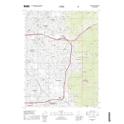
2020 Map of Sugar House
USGS Topo · Published 2020About this map
Salt Lake City and its eastern suburbs are shown at a high level of contemporary development, pressed against the dramatic vertical rise of the Wasatch Range. The neighborhood of Sugar House and the historic Forest Dale district sit at the center of a dense urban grid that transitions into the foothills of the Wasatch National Forest. This 2020 map documents the modern footprint of numerous educational institutions, including Westminster College and the Midwives College of Utah, alongside established residential communities like Canyon Rim and East Millcreek.
Find a feature on this map
68 named features on this map. Tap any name to fly to it.
Don’t see what you’re looking for? This feature index may not catch every label — zoom into the map to look around manually.
Map Details
Editions of this 2020 Sugar House Map
This is the sole edition of this map. No revisions or reprints were ever made.
Other maps of this area

1885 · Salt Lake
USGS Topo · 1:250,000

1925 · Ft. Douglas
USGS Topo · 1:125,000

1928 · Ft. Douglas
USGS Topo · 1:125,000

1950 · Fort Douglas
USGS Topo · 1:24,000

1951 · Fort Douglas
USGS Topo · 1:24,000

1951 · Salt Lake City South
USGS Topo · 1:24,000

1951 · Midvale
USGS Topo · 1:24,000

1951 · Salt Lake City North
USGS Topo · 1:24,000

1952 · Sugar House
USGS Topo · 1:24,000
1952 · Draper
USGS Topo · 1:24,000