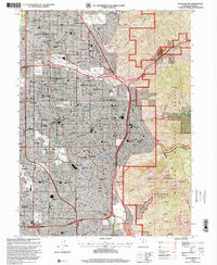
1998 Map of Sugar House
USGS Topo · Published 2001About this map
Salt Lake Valley urbanization meets the steep rise of the Wasatch Front in this late-twentieth-century revision. The map documents the dense suburban infill of eastern Salt Lake City and Murray, characterized by an extensive network of neighborhood schools like Highland High Sch and Granite High Sch, alongside landmark institutions such as Westminster College. The residential blocks of Sugar House and Holladay are defined by the passage of mountain waters including Parleys Creek and Big Cottonwood Creek, which flow toward the Jordan River. Genealogy researchers will find significant detail in the multiple interment sites, including Wasatch Lawn Memorial Park and Elysian Burial Gardens. To the east, the Wasatch National Forest boundary marks a sharp transition from the city grid to the high peaks of Grandeur Peak and Mt Olympus, where canyons like Mill Creek Canyon and Neffs Canyon incise the wilderness.
Find a feature on this map
87 named features on this map. Tap any name to fly to it.
Don’t see what you’re looking for? This feature index may not catch every label — zoom into the map to look around manually.
Map Details
Editions of this 1998 Sugar House Map
This is the sole edition of this map. No revisions or reprints were ever made.
Other maps of this area

1885 · Salt Lake
USGS Topo · 1:250,000

1925 · Ft. Douglas
USGS Topo · 1:125,000

1928 · Ft. Douglas
USGS Topo · 1:125,000

1950 · Fort Douglas
USGS Topo · 1:24,000

1951 · Fort Douglas
USGS Topo · 1:24,000

1951 · Salt Lake City South
USGS Topo · 1:24,000

1951 · Midvale
USGS Topo · 1:24,000

1951 · Salt Lake City North
USGS Topo · 1:24,000

1952 · Sugar House
USGS Topo · 1:24,000
1952 · Draper
USGS Topo · 1:24,000