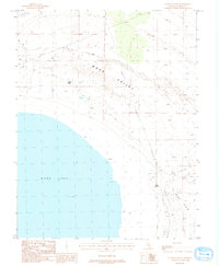
1986 Map of Sulphur Pond
USGS Topo · Published 1986About this map
Mono Lake dominates the southwestern corner of this 1980s topographical study, its expansive waters meeting a landscape of vast sand flats and desert features. The terrain transition between Mono Valley and the broader Mono Basin is clearly defined, showing the geological character of this arid region. The presence of Sulphur Pond and multiple Spring sites, including Warm Springs, highlights the critical water sources scattered across the dry valley floor.
Find a feature on this map
14 named features on this map. Tap any name to fly to it.
Don’t see what you’re looking for? This feature index may not catch every label — zoom into the map to look around manually.
Map Details
Editions of this 1986 Sulphur Pond Map
This is the sole edition of this map. No revisions or reprints were ever made.
Other maps of this area

1901 · Mt. Lyell
USGS Topo · 1:125,000

1909 · Hawthorne
USGS Topo · 1:250,000

1909 · Bridgeport
USGS Topo · 1:125,000

1911 · Bridgeport
USGS Topo · 1:125,000

1911 · Hawthorne
USGS Topo · 1:250,000

1914 · Mt. Morrison
USGS Topo · 1:125,000

1915 · Hawthorne
USGS Topo · 1:250,000

1920 · Bridgeport
USGS Topo · 1:125,000

1947 · Mariposa
USGS Topo · 1:250,000

1948 · Walker Lake
USGS Topo · 1:250,000