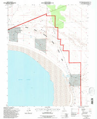
1994 Map of Sulphur Pond
USGS Topo · Published 1997About this map
The Mono Lake shoreline and the high desert of the Mono Basin define this 1994 revision. The landscape is characterized by its hydrologic features, including the eponymous Sulphur Pond, Walford Spring, and Warm Springs found near the western edge of the mountains. Transportation history is visible in the lengthy Old Railroad Grade that winds through the Mono Scenic Area, tracing a path between the lake and the rising slopes of the Mono National Forest. Resource extraction is evidenced by a scattered Prospect and several Wells located in the arid Mono Valley. The interplay of conservation and industry is evident here, as wilderness designations overlap with 4WD tracks and former industrial corridors, providing a detailed look at the eastern Sierra Nevada foothills as they appeared in the early 1990s.
Find a feature on this map
18 named features on this map. Tap any name to fly to it.
Don’t see what you’re looking for? This feature index may not catch every label — zoom into the map to look around manually.
Map Details
Editions of this 1994 Sulphur Pond Map
This is the sole edition of this map. No revisions or reprints were ever made.
Other maps of this area

1901 · Mt. Lyell
USGS Topo · 1:125,000

1909 · Hawthorne
USGS Topo · 1:250,000

1909 · Bridgeport
USGS Topo · 1:125,000

1911 · Bridgeport
USGS Topo · 1:125,000

1911 · Hawthorne
USGS Topo · 1:250,000

1914 · Mt. Morrison
USGS Topo · 1:125,000

1915 · Hawthorne
USGS Topo · 1:250,000

1920 · Bridgeport
USGS Topo · 1:125,000

1947 · Mariposa
USGS Topo · 1:250,000

1948 · Walker Lake
USGS Topo · 1:250,000