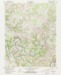
1961 Map of Summersville
USGS Topo · Published 1988About this map
Green River meanders deeply through Green County, defining a landscape shaped by both sharp limestone relief and industrial utility in the early 1960s. The map illustrates a transition from the dense agricultural and woodland plots around Summersville and Allendale to the increasingly industrial fringes of Greensburg. Notable geologic features like The Sinks of Little Brush and The Narrows of Pitman highlight the complex karst topography of the region.
Find a feature on this map
53 named features on this map. Tap any name to fly to it.
Don’t see what you’re looking for? This feature index may not catch every label — zoom into the map to look around manually.
Map Details
Editions of this 1961 Summersville Map
Other maps of this area

1953 · Saloma
USGS Topo · 1:24,000

1953 · Hudgins
USGS Topo · 1:24,000

1953 · Hibernia
USGS Topo · 1:24,000

1953 · Summersville
USGS Topo · 1:24,000

1953 · Exie
USGS Topo · 1:24,000

1953 · Magnolia
USGS Topo · 1:24,000

1953 · Gresham
USGS Topo · 1:24,000

1953 · Center
USGS Topo · 1:24,000

1954 · Greensburg
USGS Topo · 1:24,000

1957 · Winchester
USGS Topo · 1:250,000