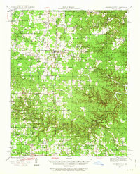
1946 Map of Summersville
USGS Topo · Published 1963About this map
Summersville serves as the central hub of this 1946 survey, located at the junction of three counties. The landscape is defined by the deep valleys and spring-fed waters of the Ozark Plateau, where Jack's Fork and Spring Creek carve through the terrain. A dense network of one-room schools like Heelstring Sch and Science Ridge Sch indicates a decentralized, rural community structure common to mid-century Missouri before the consolidation of rural school districts.
Find a feature on this map
65 named features on this map. Tap any name to fly to it.
Don’t see what you’re looking for? This feature index may not catch every label — zoom into the map to look around manually.
Map Details
Editions of this 1946 Summersville Map
2 editions found
Other maps of this area

1915 · Eminence
USGS Topo · 1:62,500

1917 · Eminence
USGS Topo · 1:62,500

1931 · Bandyville
USGS Topo · 1:48,000

1932 · Cedar Grove
USGS Topo · 1:48,000

1944 · Birch Tree
USGS Topo · 1:62,500

1945 · Willow Springs
USGS Topo · 1:62,500

1945 · Montier
USGS Topo · 1:62,500

1945 · Round Spring
USGS Topo · 1:62,500

1945 · Clear Springs
USGS Topo · 1:62,500

1946 · Summersville
USGS Topo · 1:62,500