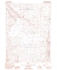
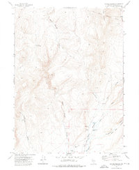
1990 Map of Summit Lake
USGS Topo · Published 1990About this map
The Summit Lake Indian Reservation anchors this high-desert landscape in northern Humboldt County. The land is marked by complex jurisdictional boundaries and ecological protections, including the Sheldon National Wildlife Refuge to the north and the Lahontan Cutthroat Trout State Natural Area protecting the waters of Summit Lake and Mahogany Creek. Cultural history is preserved at the Camp McGarry (Historical Site) and the Summit Lake Cem, while remote transit is facilitated by the Summit Lake Landing Strip and numerous 4WD tracks. High-elevation features like the Black Rock Range and Rock Spring Table overlook the arid Fivemile Flat. Water sources, critical in this environment, are meticulously noted with labels for Fivemile Spring, Onemile Spring, and the Summit Lake Well.
Find a feature on this map
38 named features on this map. Tap any name to fly to it.
Don’t see what you’re looking for? This feature index may not catch every label — zoom into the map to look around manually.
Map Details
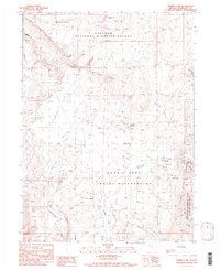
Editions of this 1990 Summit Lake Map
2 editions found
Other maps of this area

1886 · Disaster
USGS Topo · 1:250,000

1889 · Long Valley
USGS Topo · 1:250,000

1893 · Disaster
USGS Topo · 1:250,000

1954 · Vya
USGS Topo · 1:250,000

1958 · Vya
USGS Topo · 1:250,000

1962 · Vya
USGS Topo · 1:250,000
1965 · Idaho Canyon
USGS Topo · 1:62,500
1965 · Rock Spring Table
USGS Topo · 1:62,500
1972 · Soldier Meadow
USGS Topo · 1:24,000
1972 · Burnt Springs
USGS Topo · 1:24,000