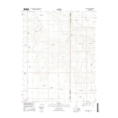
2014 Map of Summit Point
USGS Topo · Published 2014About this map
Summit Point and the surrounding high-plateau settlements of West Summit and East Summit define this high-elevation corner of San Juan County during the early 21st century. Positioned along the Utah Colorado state line, the landscape is deeply incised by drainage systems including Bear Trap Canyon and Little Indian Canyon. A network of local roads such as W Summit Rd and Ucolo Rd connects scattered farmsteads and points of interest like Rock House. The terrain is marked by significant vertical relief, where Three Step Hill rises above the Lower Lisbon Valley, and prominent landforms like Island Mesa and Horse Range Mesa dominate the eastern horizon. The mapping reveals a distinct pattern of high-desert land use, where the dry canyons of Mc Intyre Canyon and East Canyon contrast with the established agricultural summits that give the area its name.
Find a feature on this map
38 named features on this map. Tap any name to fly to it.
Don’t see what you’re looking for? This feature index may not catch every label — zoom into the map to look around manually.
Map Details
Editions of this 2014 Summit Point Map
This is the sole edition of this map. No revisions or reprints were ever made.
Other maps of this area

1885 · La Sal
USGS Topo · 1:250,000

1886 · Abajo
USGS Topo · 1:250,000

1892 · Abajo
USGS Topo · 1:250,000

1893 · Abajo
USGS Topo · 1:250,000

1916 · Paradox Valley
USGS Topo · 1:125,000

1922 · Paradox Valley
USGS Topo · 1:125,000

1948 · Horse Range Mesa
USGS Topo · 1:24,000

1949 · Egnar
USGS Topo · 1:24,000
1949 · Anderson Mesa
USGS Topo · 1:24,000

1950 · Horse Range Mesa
USGS Topo · 1:24,000