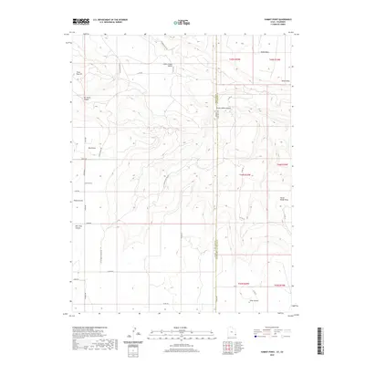
2020 Map of Summit Point
USGS Topo · Published 2020About this map
Summit Point sits at the center of this high-desert landscape along the Utah-Colorado border, representing a remote agricultural and ranching outpost in San Juan County. The terrain is defined by a series of dramatic mesas and canyons, including Island Mesa in the northeast and the deep cuts of Mc Intyre Canyon and Bear Trap Canyon to the west. A complex network of rural roads like Ucolo Rd and Lisbon Valley Rd connects the scattered homesteads of the area to the nearby West Summit settlement. The map reveals a land structured by both natural geology and human survey, with the winding Little Indian Canyon and Buck Draw contrasted against the rigid section lines of the Public Land Survey System. The proximity to the Lower Lisbon Valley suggests a history tied to the regional mining and grazing economy that has long sustained these borderland communities.
Find a feature on this map
37 named features on this map. Tap any name to fly to it.
Don’t see what you’re looking for? This feature index may not catch every label — zoom into the map to look around manually.
Map Details
Editions of this 2020 Summit Point Map
This is the sole edition of this map. No revisions or reprints were ever made.
Other maps of this area

1885 · La Sal
USGS Topo · 1:250,000

1886 · Abajo
USGS Topo · 1:250,000

1892 · Abajo
USGS Topo · 1:250,000

1893 · Abajo
USGS Topo · 1:250,000

1916 · Paradox Valley
USGS Topo · 1:125,000

1922 · Paradox Valley
USGS Topo · 1:125,000

1948 · Horse Range Mesa
USGS Topo · 1:24,000

1949 · Egnar
USGS Topo · 1:24,000
1949 · Anderson Mesa
USGS Topo · 1:24,000

1950 · Horse Range Mesa
USGS Topo · 1:24,000