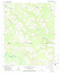
1966 Map of Sunbeam
USGS Topo · Published 1980About this map
The Meherrin River defines the southern reaches of this landscape, carving through a region where the borders of Southampton County, Virginia, meet Hertford and Northampton Counties in North Carolina. The settlement of Newsoms sits in the northwest corner, while rural life centers around dispersed communities like Sunbeam and Statesville. The terrain is characterized by intricate drainage systems such as Darden Mill Run and Buckhorn Creek, feeding into larger bodies like the Windbourne Millpond.
Find a feature on this map
27 named features on this map. Tap any name to fly to it.
Don’t see what you’re looking for? This feature index may not catch every label — zoom into the map to look around manually.
Map Details
Editions of this 1966 Sunbeam Map
2 editions found
Other maps of this area

1908 · Winton
USGS Topo · 1:62,500

1919 · Boykins
USGS Topo · 1:48,000

1920 · Holland
USGS Topo · 1:62,500

1920 · Boykins
USGS Topo · 1:62,500

1943 · Holland
USGS Topo · 1:62,500

1953 · Norfolk
USGS Topo · 1:250,000

1957 · Holland
USGS Topo · 1:62,500
1966 · Capron
USGS Topo · 1:24,000

1966 · Sunbeam
USGS Topo · 1:24,000
1966 · Boykins
USGS Topo · 1:24,000