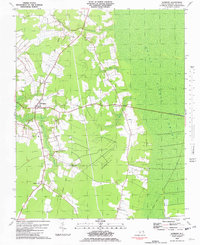
1981 Map of Sunbury
USGS Topo · Published 1982About this map
Sunbury stands as the primary hub of this Gates County landscape, situated at the intersection of rural routes and surrounded by the low-lying wetlands of the coastal plain. The eastern portion of the map is dominated by the vast, wooded expanse of the Great Dismal Swamp, a defining environmental feature of the region. Local industry and historic transport are evidenced by the Acorn Hill Millpond and an Old Railroad Grade that cuts through the terrain near Kellogs Fork. Smaller agrarian settlements like Wardville, Acorn Hill, and Hoflers Fork are scattered throughout, often anchored by community landmarks such as Oak Grove Ch and St Johns Zion Ch. Genealogists will find numerous unnamed Cem and Graves sites distributed across family lands, particularly along the winding courses of Folly Swamp and Raynor Swamp.
Find a feature on this map
17 named features on this map. Tap any name to fly to it.
Don’t see what you’re looking for? This feature index may not catch every label — zoom into the map to look around manually.
Map Details
Editions of this 1981 Sunbury Map
This is the sole edition of this map. No revisions or reprints were ever made.
Other maps of this area

1906 · Beckford
USGS Topo · 1:48,000

1907 · Beckford
USGS Topo · 1:62,500

1919 · Suffolk
USGS Topo · 1:62,500

1940 · Beckford
USGS Topo · 1:62,500

1940 · Lake Drummond
USGS Topo · 1:62,500

1940 · South Mills
USGS Topo · 1:62,500

1945 · Lake Drummond
USGS Topo · 1:62,500

1952 · South Mills
USGS Topo · 1:62,500

1953 · Norfolk
USGS Topo · 1:250,000

1954 · Corapeake
USGS Topo · 1:24,000