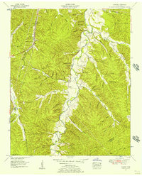
1952 Map of Sunrise
USGS Topo · Published 1957About this map
Big Swan Creek carves a deep path through this portion of the Highland Rim, defining a landscape of narrow hollows and steep ridges in southern Hickman County. The mid-century settlement pattern is clustered around small rural centers like Sunrise and Swan Bluff, where local life centered on the Sunrise Sch and Campground Ch. To the west, the Nashville Chattanooga & St Louis railway skirts the edge of Little Piney Creek, providing a vital industrial link through the timber-rich terrain. Family history is well-preserved through numerous upland burial grounds, including the Whiteside Cem and Anderson Cem. The transition from local transit to regional connectivity is marked by the presence of the Jim Mc Cord Highway in the north, while the southern boundary follows the Hickman and Lewis County line near Jenkins Falls and the geological openings of Big Cave and Bat Cave.
Find a feature on this map
71 named features on this map. Tap any name to fly to it.
Don’t see what you’re looking for? This feature index may not catch every label — zoom into the map to look around manually.
Map Details
Editions of this 1952 Sunrise Map
2 editions found
Other maps of this area

1901 · Colombia
USGS Topo · 1:125,000

1936 · Mt Joy
USGS Topo · 1:24,000

1936 · Beaverdam Springs
USGS Topo · 1:24,000

1936 · Nunnelly
USGS Topo · 1:24,000

1936 · Whitfield
USGS Topo · 1:24,000

1936 · Sunrise
USGS Topo · 1:24,000

1936 · Littlelot
USGS Topo · 1:24,000

1936 · Greenfield Bend
USGS Topo · 1:24,000

1936 · Kimmins
USGS Topo · 1:24,000

1936 · Gordonsburg
USGS Topo · 1:24,000