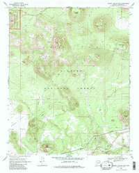
1969 Map of Sunset Crater East
USGS Topo · Published 1984About this map
The volcanic topography of the Cinder Hills dominates this 1960s survey of Coconino County, defined by a landscape of distinct cinder cones and basins. The western edge captures the margin of the Sunset Crater National Monument, while the surrounding terrain is marked by geological formations such as Double Crater, Stewart Crater, and the sharp rise of Cochrane Hill. This area, situated within the Coconino National Forest, illustrates the intersection of natural volcanic history and human presence, from ancient Ruins near O'Neill Crater to modern infrastructure like the pipelines and Leupp Road. Cultural and industrial markers include the Cinder Pit and Turkey Tanks, while the drainage patterns of Kana a Wash and San Francisco Wash cut through the arid volcanic basins of Little Cinder Basin and Cinder Basin.
Find a feature on this map
28 named features on this map. Tap any name to fly to it.
Don’t see what you’re looking for? This feature index may not catch every label — zoom into the map to look around manually.
Map Details
Editions of this 1969 Sunset Crater East Map
3 editions found
Other maps of this area

1886 · San Francisco Mtns
USGS Topo · 1:250,000

1891 · San Francisco Mtns
USGS Topo · 1:250,000

1894 · San Francisco Mtns
USGS Topo · 1:250,000

1899 · San Francisco Mtns
USGS Topo · 1:250,000

1908 · Flagstaff
USGS Topo · 1:125,000

1912 · Flagstaff
USGS Topo · 1:125,000

1947 · Flagstaff
USGS Topo · 1:250,000

1954 · Flagstaff
USGS Topo · 1:250,000

1958 · Flagstaff
USGS Topo · 1:250,000

1960 · Flagstaff
USGS Topo · 1:250,000