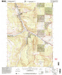
2000 Map of Sunshine Point
USGS Topo · Published 2005About this map
The Gallatin River carves a central path through this mountain landscape at the turn of the millennium, serving as the primary corridor for movement between the Bozeman Ranger District and the Hebgen Lake Ranger District. Human presence is concentrated in small outposts like Almart, Cinnamon Station, and the historic 320 Ranch, highlighting a transition from traditional ranching to a landscape defined by conservation and recreation.
Find a feature on this map
37 named features on this map. Tap any name to fly to it.
Don’t see what you’re looking for? This feature index may not catch every label — zoom into the map to look around manually.
Map Details
Editions of this 2000 Sunshine Point Map
This is the sole edition of this map. No revisions or reprints were ever made.
Other maps of this area

1888 · Three Forks
USGS Topo · 1:250,000

1894 · Three Forks
USGS Topo · 1:250,000

1895 · Three Forks
USGS Topo · 1:250,000

1947 · Bozeman
USGS Topo · 1:250,000

1948 · Bozeman
USGS Topo · 1:250,000

1950 · Hebgen Dam
USGS Topo · 1:62,500

1950 · Sphinx Mountain
USGS Topo · 1:62,500

1955 · Bozeman
USGS Topo · 1:250,000

1955 · Crown Butte
USGS Topo · 1:62,500

1955 · Ashton
USGS Topo · 1:250,000