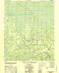
1950 Map of Supply
USGS Topo · Published 1951About this map
Green Swamp dominates the northern reaches of this coastal North Carolina landscape, where early timber and transit routes like the Old Tram Road and Driving Creek Road once cut through the dense wetlands. The map illustrates a transitional period in Waccamaw Township, showing how the dispersed settlements of Prospect and Supply were linked by a network of rural roads such as Prospect Road and Beach Road. Along the winding Lockwoods Folly River and its numerous tributaries, including Royal Oak Swamp and Doe Creek, local life centered around community landmarks like Royal Oak School, Macedonia Ch, and Concord Church. The inclusion of Royal Oak Bridge and Lockwoods Folly Bridge highlights the critical infrastructure required to navigate the area's intricate system of bays and marshes, including Huitt Bay and Cumbee Bay.
Find a feature on this map
42 named features on this map. Tap any name to fly to it.
Don’t see what you’re looking for? This feature index may not catch every label — zoom into the map to look around manually.
Map Details
Editions of this 1950 Supply Map
This is the sole edition of this map. No revisions or reprints were ever made.
Other maps of this area

1942 · Juniper Creek
USGS Topo · 1:24,000

1943 · Honey Island
USGS Topo · 1:24,000

1943 · Holden Beach
USGS Topo · 1:24,000

1943 · Exum
USGS Topo · 1:24,000

1943 · Bolivia
USGS Topo · 1:24,000

1943 · Lockwoods Folly
USGS Topo · 1:24,000

1943 · Supply
USGS Topo · 1:24,000

1943 · Lewis Swamp
USGS Topo · 1:24,000

1943 · Shallotte
USGS Topo · 1:24,000

1944 · Supply
USGS Topo · 1:31,680