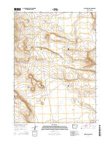
2014 Map of Surveyors Lake
USGS Topo · Published 2014About this map
Surveyors Lake sits at the heart of this high-desert landscape in Harney County, illustrating the remote and arid character of southeastern Oregon. The terrain is defined by dramatic contour changes and public land divisions, including portions of t37s r29e, t37s r30e, and t38s r30e. Significant geographic markers like Butcher Flat provide orientation in a region largely devoid of permanent settlements, reflecting the isolation of the Oregon outback. Human presence is primarily indicated by the inclusion of NF-6176, a forest service road that navigates the complex topography. This map captures the intersection of natural water features and the established Public Land Survey System, serving as a detailed record of the physical environment before more recent ecological shifts in the high desert basin.
Find a feature on this map
7 named features on this map. Tap any name to fly to it.
Don’t see what you’re looking for? This feature index may not catch every label — zoom into the map to look around manually.
Map Details
Editions of this 2014 Surveyors Lake Map
This is the sole edition of this map. No revisions or reprints were ever made.
Other maps of this area

1955 · Adel
USGS Topo · 1:250,000

1957 · Adel
USGS Topo · 1:250,000

1958 · Adel
USGS Topo · 1:250,000

1962 · Adel
USGS Topo · 1:250,000

1971 · Fish Fin Rim
USGS Topo · 1:24,000
1971 · Acty Mountain NW
USGS Topo · 1:24,000

1971 · Beatys Butte
USGS Topo · 1:24,000

1971 · Surveyors Lake
USGS Topo · 1:24,000

1971 · Coyote Gap SE
USGS Topo · 1:24,000

1971 · Mahogany Butte
USGS Topo · 1:24,000