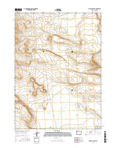
2017 Map of Surveyors Lake
USGS Topo · Published 2017About this map
Surveyors Lake sits within a sparsely populated expanse of the high desert in Harney County, characterized by seasonal water bodies and flat-bottomed basins. In the southern portion of the quadrangle, Shallow Lake marks a broad depression in the landscape, likely reflecting the ephemeral hydrology common to the region. This 2017 survey documents a geography defined by open terrain and limited infrastructure, where access is provided primarily by rugged thoroughfares like D L Spring Rd and Nat For Dev Rd 6176. The presence of Butcher Flat further emphasizes the plateau-like character of the area, serving as a reminder of the historical livestock and grazing patterns that have long shaped the land-use history of this corner of Oregon.
Find a feature on this map
9 named features on this map. Tap any name to fly to it.
Don’t see what you’re looking for? This feature index may not catch every label — zoom into the map to look around manually.
Map Details
Editions of this 2017 Surveyors Lake Map
This is the sole edition of this map. No revisions or reprints were ever made.
Other maps of this area

1955 · Adel
USGS Topo · 1:250,000

1957 · Adel
USGS Topo · 1:250,000

1958 · Adel
USGS Topo · 1:250,000

1962 · Adel
USGS Topo · 1:250,000

1971 · Fish Fin Rim
USGS Topo · 1:24,000
1971 · Acty Mountain NW
USGS Topo · 1:24,000

1971 · Beatys Butte
USGS Topo · 1:24,000

1971 · Surveyors Lake
USGS Topo · 1:24,000

1971 · Coyote Gap SE
USGS Topo · 1:24,000

1971 · Mahogany Butte
USGS Topo · 1:24,000