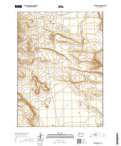
2020 Map of Surveyors Lake
USGS Topo · Published 2020About this map
Surveyors Lake and the seasonally fluctuating Shallow Lake define this high-desert basin in southeastern Oregon. This remote corner of Harney County is largely characterized by expansive flats and subtle depressions that gather moisture in an otherwise arid landscape. The area is mapped with precision by the U.S. Geological Survey, capturing the sparse infrastructure that supports the region, such as D L Spring Rd and Nat For Dev Rd 6176. The terrain gradually transitions into the broad expanse of Butcher Flat in the southeast, a landform typical of the Great Basin’s geological character. These features provide essential landmarks for navigation across the vast stretches of open rangeland, reflecting the area's continued use for land management and seasonal grazing.
Find a feature on this map
10 named features on this map. Tap any name to fly to it.
Don’t see what you’re looking for? This feature index may not catch every label — zoom into the map to look around manually.
Map Details
Editions of this 2020 Surveyors Lake Map
This is the sole edition of this map. No revisions or reprints were ever made.
Other maps of this area

1955 · Adel
USGS Topo · 1:250,000

1957 · Adel
USGS Topo · 1:250,000

1958 · Adel
USGS Topo · 1:250,000

1962 · Adel
USGS Topo · 1:250,000

1971 · Fish Fin Rim
USGS Topo · 1:24,000
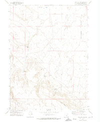
1971 · Acty Mountain NW
USGS Topo · 1:24,000

1971 · Beatys Butte
USGS Topo · 1:24,000

1971 · Surveyors Lake
USGS Topo · 1:24,000

1971 · Coyote Gap SE
USGS Topo · 1:24,000

1971 · Mahogany Butte
USGS Topo · 1:24,000