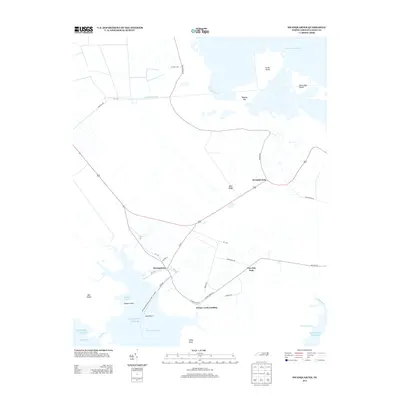
2013 Map of Swanquarter
USGS Topo · Published 2013About this map
Swanquarter and the surrounding Hyde County landscape are defined by a complex network of coastal waterways and engineered drainage. The presence of the Rose Bay Canal and various inlets like Deep Bay and Swanquarter Bay illustrate the area's long-standing relationship with the Atlantic Ocean. The map reveals a settlement pattern focused on crossroads and landings, such as Swindell Fork, Tiny Oak Fork, and Oyster Creek Landing. Large-scale coastal features like Lake Mattamuskeet and Great Island dominate the northern and eastern portions of the sheet, while the Swan Quarter-Ocracoke Ferry Crossing highlights the vital maritime transit links required for this wetland-heavy terrain. Local roads, including Turnpike Rd and Piney Woods Rd, connect these coastal outposts across landforms like Buck Ridge and Tapping Hill.
Find a feature on this map
41 named features on this map. Tap any name to fly to it.
Don’t see what you’re looking for? This feature index may not catch every label — zoom into the map to look around manually.
Map Details
Editions of this 2013 Swanquarter Map
This is the sole edition of this map. No revisions or reprints were ever made.
Other maps of this area

1943 · Columbia
USGS Topo · 1:125,000
1951 · Bluff Point
USGS Topo · 1:24,000

1951 · Pamlico Point
USGS Topo · 1:24,000

1951 · Great Island
USGS Topo · 1:24,000

1951 · Scranton
USGS Topo · 1:24,000

1951 · New Holland
USGS Topo · 1:24,000

1951 · Swanquarter
USGS Topo · 1:24,000

1951 · Fairfield
USGS Topo · 1:24,000

1951 · Ponzer
USGS Topo · 1:24,000

1951 · New Lake SE
USGS Topo · 1:24,000