
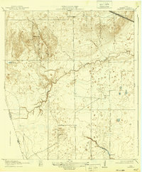
1919 Map of Swanson
USGS Topo · Published 1919About this map
Warren Ranch sits amidst a network of prairie drainages and low rises in this 1919 survey of the coastal plain northwest of Houston. This preliminary edition, surveyed in cooperation with Harris County, reveals a landscape defined by seasonal watercourses like Cypress Creek and the meandering Bear Creek. The topography is subtle but distinct, featuring the modest elevation of Wolf Hill and numerous depressions across the flats. Evidence of early water management is visible at Freemans Dam in the southeast. Transport is dictated by the regional rail and road corridors, most notably the Southern Pacific System (Houston and Texas Central RR) and the Houston and Hempstead Road, which cut through the northern portion of the sheet. The map provides a detailed look at the boundary between Harris and Waller counties before significant modern development altered the drainage patterns of these prairie lands.
Find a feature on this map
13 named features on this map. Tap any name to fly to it.
Don’t see what you’re looking for? This feature index may not catch every label — zoom into the map to look around manually.
Map Details
Editions of this 1919 Swanson Map
2 editions found
Other maps of this area

1915 · Cypress
USGS Topo · 1:24,000

1915 · Katy
USGS Topo · 1:24,000

1915 · Addicks
USGS Topo · 1:24,000

1916 · Rose Hill
USGS Topo · 1:24,000

1916 · Hockley
USGS Topo · 1:24,000

1916 · Swanson
USGS Topo · 1:24,000

1918 · Cypress
USGS Topo · 1:31,680

1918 · Addicks
USGS Topo · 1:31,680

1920 · Hockley
USGS Topo · 1:31,680

1920 · Rose Hill
USGS Topo · 1:31,680