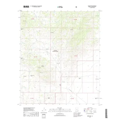
2018 Map of Swede Peak
USGS Topo · Published 2018About this map
Coronado National Forest lands dominate this high-desert landscape in the late 2010s, where the eastern slopes of the Chiricahua Mountains descend toward the San Simon Valley and San Bernardino Valley. The terrain is defined by a series of steep drainages including Rustler Canyon, Box Canyon, and Tex Canyon, which cut through elevations marked by Swede Peak and Limestone Mtn. This arid environment relies on scattered water sources, often identified by names like High Lonesome Spring and Cottonwood Spring, or artificial catchments such as Sunset Tank, Upper Tex Tank, and Juniper Tree Tank. The mapping shows a remote area primarily accessible via E Rucker Canyon Rd, illustrating the intersection of protected forest lands and the open valley floor in Cochise County.
Find a feature on this map
39 named features on this map. Tap any name to fly to it.
Don’t see what you’re looking for? This feature index may not catch every label — zoom into the map to look around manually.
Map Details
Editions of this 2018 Swede Peak Map
This is the sole edition of this map. No revisions or reprints were ever made.
Other maps of this area

1917 · Chiricahua
USGS Topo · 1:125,000

1919 · Chiricahua
USGS Topo · 1:125,000

1926 · Rodeo
USGS Topo · 1:62,500

1926 · Rucker
USGS Topo · 1:62,500

1926 · Pedregosa
USGS Topo · 1:62,500

1940 · Apache
USGS Topo · 1:62,500

1955 · Douglas
USGS Topo · 1:250,000

1958 · Chiricahua Peak
USGS Topo · 1:62,500

1958 · Apache
USGS Topo · 1:62,500
1958 · Pedregosa Mountains
USGS Topo · 1:62,500