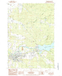
1984 Map of Sweet Home
USGS Topo · Published 1985About this map
Berlin lies at the northern edge of this study of the South Santiam River valley, a region defined by its timbered ridges and significant water resources. The landscape is dominated by the Foster Lake reservoir, formed by the Foster Dam, which fundamentally reshaped the local geography and infrastructure during the mid-20th century. Detailed topographic work captures the industrial and community layout of Sweet Home, including its educational centers like Oak Heights Sch and Hawthorne Sch. The map tracks the passage of the Oregon and Northwestern Railroad and the development of local landmarks such as the Andrew Wiley Park and Gilland Cem. This record of the Santiam River corridor provides a clear look at how water management and the timber industry shaped the residential patterns of eastern Linn County.
Find a feature on this map
1 named feature on this map. Tap any name to fly to it.
Don’t see what you’re looking for? This feature index may not catch every label — zoom into the map to look around manually.
Map Details
Editions of this 1984 Sweet Home Map
This is the sole edition of this map. No revisions or reprints were ever made.
Other maps of this area

1921 · Brownsville
USGS Topo · 1:62,500

1921 · Lebanon
USGS Topo · 1:62,500

1922 · Lebanon
USGS Topo · 1:48,000

1924 · Lebanon
USGS Topo · 1:62,500

1940 · Lebanon
USGS Topo · 1:62,500

1944 · Lebanon
USGS Topo · 1:62,500

1950 · Brownsville
USGS Topo · 1:62,500

1951 · Sweet Home
USGS Topo · 1:62,500

1951 · Snow Peak
USGS Topo · 1:62,500

1952 · Brownsville
USGS Topo · 1:62,500