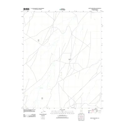
2011 Map of Sweetwater Mesa
USGS Topo · Published 2011About this map
Sweetwater Mesa and the surrounding high desert of Apache County are defined by striking geological formations and an intricate network of tribal routes. This 2011 survey illustrates the sparse but critical water resources in the arid landscape, notably Al Tse Toh and Toh Ah Glau, which are essential markers in this high-plateau environment. The terrain is anchored by massive landmarks such as White Rock Mesa in the northwest and the distinctive Three Black Rocks to the south. A complex system of roadways, including Indian Rte 18 and Indian Rte 59, crisscrosses the quadrangle, reflecting the modern transportation infrastructure serving this part of the Navajo Nation. The map captures the intersection of traditional land navigation and contemporary roadway development, preserving the specific nomenclature of the region's mesas and washes.
Find a feature on this map
8 named features on this map. Tap any name to fly to it.
Don’t see what you’re looking for? This feature index may not catch every label — zoom into the map to look around manually.
Map Details
Editions of this 2011 Sweetwater Mesa Map
This is the sole edition of this map. No revisions or reprints were ever made.
Other maps of this area

1883 · Marsh Pass
USGS Topo · 1:250,000

1892 · Marsh Pass
USGS Topo · 1:250,000

1892 · Canyon De Chelly
USGS Topo · 1:250,000

1954 · Shiprock
USGS Topo · 1:250,000

1956 · Marble Canyon
USGS Topo · 1:250,000

1958 · Shiprock
USGS Topo · 1:250,000

1959 · Shiprock
USGS Topo · 1:250,000

1959 · Marble Canyon
USGS Topo · 1:250,000

1961 · Marble Canyon
USGS Topo · 1:250,000
1968 · Chilchinbito
USGS Topo · 1:24,000