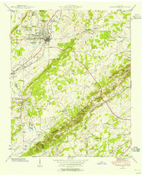
1941 Map of Sweetwater
USGS Topo · Published 1954About this map
Sweetwater serves as the primary hub on this 1941 survey, where the Southern railroad and the Lee Highway intersect. The town's social and educational fabric is defined by the prominent Tennessee Military Institute and a network of neighborhood schools including High Point Sch. To the south, the landscape transitions into the distinctive geology of The Knobs, a series of ridges harboring landmarks like Craighead Caverns and Craighead Lake.
Find a feature on this map
36 named features on this map. Tap any name to fly to it.
Don’t see what you’re looking for? This feature index may not catch every label — zoom into the map to look around manually.
Map Details
Editions of this 1941 Sweetwater Map
This is the sole edition of this map. No revisions or reprints were ever made.
Other maps of this area

1886 · Cleveland
USGS Topo · 1:125,000

1887 · Kingston
USGS Topo · 1:125,000

1891 · Kingston
USGS Topo · 1:125,000

1892 · Cleveland
USGS Topo · 1:125,000

1893 · Murphy
USGS Topo · 1:125,000

1893 · Kingston
USGS Topo · 1:125,000

1895 · Cleveland
USGS Topo · 1:125,000

1895 · Loudon
USGS Topo · 1:125,000

1901 · Cleveland
USGS Topo · 1:125,000

1914 · Murphy
USGS Topo · 1:125,000