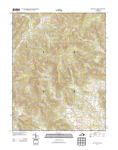
2013 Map of Swift Run Gap
USGS Topo · Published 2013About this map
Shenandoah National Park dominates this portion of the Blue Ridge, where the historic Skyline Dr winds through high mountain passes like Swift Run Gap and Simmons Gap. This 2013 survey illustrates the rugged interface between protected federal lands and the rural valley communities of Rockingham and Greene Counties. The mountain landscape is dotted with numerous hollows and gaps that historically dictated travel and settlement patterns, such as Bacon Hollow and Smith Roach Gap.
Find a feature on this map
131 named features on this map. Tap any name to fly to it.
Don’t see what you’re looking for? This feature index may not catch every label — zoom into the map to look around manually.
Map Details
Editions of this 2013 Swift Run Gap Map
This is the sole edition of this map. No revisions or reprints were ever made.
Other maps of this area

1892 · Gordonsville
USGS Topo · 1:125,000

1892 · Harrisonburg
USGS Topo · 1:125,000

1930 · Madison
USGS Topo · 1:48,000

1931 · University
USGS Topo · 1:62,500

1933 · Madison
USGS Topo · 1:62,500

1935 · Charlottesville
USGS Topo · 1:62,500

1935 · University
USGS Topo · 1:62,500

1937 · Elkton
USGS Topo · 1:62,500

1939 · Charlottesville
USGS Topo · 1:62,500

1949 · Charlottesville
USGS Topo · 1:250,000