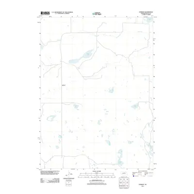
2011 Map of Sybrant
USGS Topo · Published 2011About this map
Sybrant and the surrounding Rock County landscape are defined by the intricate hydrologic patterns of the Nebraska Sandhills. In the northern reaches, Holt Creek winds eastward through a network of local roads that trace the section lines of the rural township. The terrain is dotted with numerous small bodies of water and several larger named basins, including Smith Lake, Frazier Lake, and Lanz Lake. These water features, alongside Cash Lake and Murphy Lake, illustrate the high water table and depression-fed drainage typical of this region. The settlement of Sybrant itself serves as the focal point for this sparsely populated area, where the intersection of north-south and east-west thoroughfares reflects the organized agricultural and ranching legacy of northern Nebraska in the early twenty-first century.
Find a feature on this map
7 named features on this map. Tap any name to fly to it.
Don’t see what you’re looking for? This feature index may not catch every label — zoom into the map to look around manually.
Map Details
Editions of this 2011 Sybrant Map
This is the sole edition of this map. No revisions or reprints were ever made.
Other maps of this area

1955 · O'Neill
USGS Topo · 1:250,000

1959 · O'Neill
USGS Topo · 1:250,000

1969 · O'Neill
USGS Topo · 1:250,000

1981 · Bruner Lake
USGS Topo · 1:24,000

1981 · Stonehouse Ranch NW
USGS Topo · 1:24,000

1981 · Stonehouse Ranch NE
USGS Topo · 1:24,000
1982 · Linke Lake
USGS Topo · 1:24,000

1982 · Stockdale Lake
USGS Topo · 1:24,000

1982 · Sybrant
USGS Topo · 1:24,000

1982 · Dora Lake
USGS Topo · 1:24,000