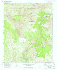
1973 Map of Sycamore Basin
USGS Topo · Published 1977About this map
Sycamore Canyon Wilderness defines the dramatic meeting point of several national forests in the early 1970s. This landscape is characterized by a complex network of water management features, such as Indian Tank, Cliff Tank, and Railroad Tank, which were essential for ranching and travel in this arid environment. The map details the transition between Kaibab National Forest, Prescott National Forest, and Coconino National Forest, showing how the boundaries converge near Sycamore Canyon.
Find a feature on this map
40 named features on this map. Tap any name to fly to it.
Don’t see what you’re looking for? This feature index may not catch every label — zoom into the map to look around manually.
Map Details
Editions of this 1973 Sycamore Basin Map
2 editions found
Other maps of this area

1886 · San Francisco Mtns
USGS Topo · 1:250,000

1886 · Chino
USGS Topo · 1:250,000

1887 · Verde
USGS Topo · 1:250,000

1887 · Prescott
USGS Topo · 1:250,000

1891 · San Francisco Mtns
USGS Topo · 1:250,000

1891 · Chino
USGS Topo · 1:250,000

1892 · Verde
USGS Topo · 1:250,000

1892 · Prescott
USGS Topo · 1:250,000

1894 · San Francisco Mtns
USGS Topo · 1:250,000

1899 · San Francisco Mtns
USGS Topo · 1:250,000