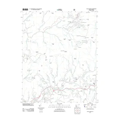
2011 Map of Sylva North
USGS Topo · Published 2011About this map
Plott Balsams and the high ridges of the Smoky Mountains dominate this landscape, where the Blue Ridge Pkwy winds past numerous overlooks such as Waterrock Knob Overlook and Thunderstruck Ridge Overlook. Down in the valleys, the headwaters of Soco Creek and Scott Creek provide the framework for small communities like Beta, Addie, and Fisher Creek. The map provides significant detail for genealogists, marking family-named sites such as Dills Cemetery, Keener Cemetery, and Norman-Blanton Cemetery. Many roads bear the names of early settlers, including Allen Henson Cir and Posey Blanton Rd. This 2011 survey captures the intersection of tourism and local heritage, showing the proximity of the Parkway to established mountain settlements and landmarks like Soco Falls and Pinnacle Bald.
Find a feature on this map
148 named features on this map. Tap any name to fly to it.
Don’t see what you’re looking for? This feature index may not catch every label — zoom into the map to look around manually.
Map Details
Editions of this 2011 Sylva North Map
This is the sole edition of this map. No revisions or reprints were ever made.
Other maps of this area

1891 · Cowee
USGS Topo · 1:125,000

1893 · Mt Guyot
USGS Topo · 1:125,000

1897 · Cowee
USGS Topo · 1:125,000

1907 · Cowee
USGS Topo · 1:125,000

1912 · Mt Guyot
USGS Topo · 1:125,000

1933 · Bryson
USGS Topo · 1:62,500

1935 · Dellwood
USGS Topo · 1:24,000

1935 · Tuckaseigee
USGS Topo · 1:24,000

1935 · Hazelwood
USGS Topo · 1:24,000

1935 · Cullowhee
USGS Topo · 1:24,000