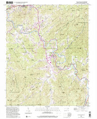
2000 Map of Sylva South
USGS Topo · Published 2001About this map
The Tuckasegee River winds through the heart of Jackson County, anchoring a landscape where academic growth and rural mountain history intersect. At the center of this map, the sprawling campus of Western Carolina University defines the community of Cullowhee, showing the specialized infrastructure required for a major educational institution in a mountain valley. Surrounding this hub are smaller, older settlements like Webster and East Laport, which reflect the region's earlier 20th-century development patterns. Family history is well-preserved across the ridges and coves, with several burial sites such as Parris Cem, Stillwell Cem, and Wyke Cem situated near historic congregations like Mt Carmel Ch. The terrain transitions from the broad river valleys to the high peaks of the Great Balsam Mountains and Cowee Mountains, much of which is protected within the Nantahala National Forest.
Find a feature on this map
66 named features on this map. Tap any name to fly to it.
Don’t see what you’re looking for? This feature index may not catch every label — zoom into the map to look around manually.
Map Details
Editions of this 2000 Sylva South Map
This is the sole edition of this map. No revisions or reprints were ever made.
Other maps of this area

1891 · Cowee
USGS Topo · 1:125,000

1897 · Cowee
USGS Topo · 1:125,000

1907 · Cowee
USGS Topo · 1:125,000

1933 · Bryson
USGS Topo · 1:62,500

1935 · Tuckaseigee
USGS Topo · 1:24,000

1935 · Hazelwood
USGS Topo · 1:24,000

1935 · Cullowhee
USGS Topo · 1:24,000

1935 · Addie
USGS Topo · 1:24,000

1935 · Glenville
USGS Topo · 1:24,000

1935 · Corbin Knob
USGS Topo · 1:24,000