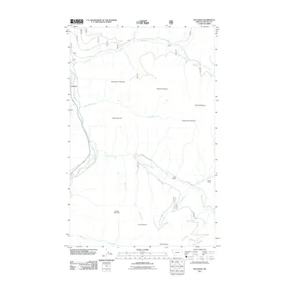
2011 Map of Sylvanite
USGS Topo · Published 2011About this map
Sylvanite anchors the western edge of this landscape where the Yaak River flows through the steep Kootenai National Forest terrain. This survey illustrates a complex network of forest access routes and drainage systems, essential for understanding the historical development of the region's logging and mining activities. Significant peaks including Independence Mountain, Skookum Mountain, and Roderick Mountain define the high country, separated by narrow drainages like Seventeenmile Creek and Vivian Creek. The mapping reveals a rugged interior where landmarks such as Crum Gulch and Grush Gulch sit alongside named summits like Dooley Mountain and Pleasant View Mountain. Genealogists and local historians can trace the paths of old forest service roads, including Seventeen Mile Creek Rd, which provide context for the remote settlements and family-named features of northwestern Montana.
Find a feature on this map
26 named features on this map. Tap any name to fly to it.
Don’t see what you’re looking for? This feature index may not catch every label — zoom into the map to look around manually.
Map Details
Editions of this 2011 Sylvanite Map
This is the sole edition of this map. No revisions or reprints were ever made.
Other maps of this area

1957 · Kalispell
USGS Topo · 1:250,000

1960 · Kalispell
USGS Topo · 1:250,000

1961 · Kalispell
USGS Topo · 1:250,000

1963 · Yaak
USGS Topo · 1:24,000

1963 · Turner Mountain
USGS Topo · 1:24,000

1963 · Sylvanite
USGS Topo · 1:24,000

1963 · Mount Baldy
USGS Topo · 1:24,000

1963 · Pulpit Mountain
USGS Topo · 1:24,000
1963 · Newton Mountain
USGS Topo · 1:24,000

1963 · Clark Mountain
USGS Topo · 1:24,000