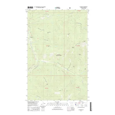
2017 Map of Sylvanite
USGS Topo · Published 2017About this map
Sylvanite sits at the edge of the Yaak River in this modern topographical study of northwestern Montana's remote interior. Located within the Kootenai National Forest, the landscape is dominated by the massive crests of the Purcell Mountains, including Grizzly Mountain, Independence Mtn, and Conn Mtn. The map highlights a complex network of forest access points like Seventenmile Creek Rd and the Skyline NRT (Skyline Ridge), which trace the steep ridgelines above drainages such as Burnt Cr and Independence Creek. This 2017 survey reflects the area's continued identity as a critical timber and backcountry region, where the historical footprint of mining and forestry is preserved through labels like Roderick Ridge/Independence and the many named gulches like Grush Gulch and Crum Gulch.
Find a feature on this map
42 named features on this map. Tap any name to fly to it.
Don’t see what you’re looking for? This feature index may not catch every label — zoom into the map to look around manually.
Map Details
Editions of this 2017 Sylvanite Map
This is the sole edition of this map. No revisions or reprints were ever made.
Other maps of this area

1957 · Kalispell
USGS Topo · 1:250,000

1960 · Kalispell
USGS Topo · 1:250,000

1961 · Kalispell
USGS Topo · 1:250,000

1963 · Yaak
USGS Topo · 1:24,000

1963 · Turner Mountain
USGS Topo · 1:24,000

1963 · Sylvanite
USGS Topo · 1:24,000

1963 · Mount Baldy
USGS Topo · 1:24,000

1963 · Pulpit Mountain
USGS Topo · 1:24,000
1963 · Newton Mountain
USGS Topo · 1:24,000

1963 · Clark Mountain
USGS Topo · 1:24,000