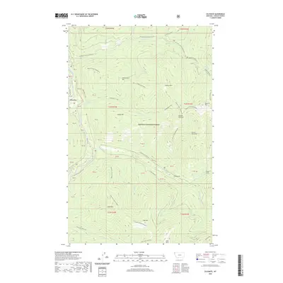
2020 Map of Sylvanite
USGS Topo · Published 2020About this map
Sylvanite sits along the Yaak River in this northern Montana landscape, where the valley floor provides a narrow corridor for settlement within the Kootenai National Forest. The map is defined by the high, ridged terrain of the Purcell Mountains, including peaks such as Grizzly Mountain, Skookum Mtn, and Independence Mtn. A network of Forest Service routes, including Yaak River Rd and the 17 Mile Creek Rd, connects these isolated drainages.
Find a feature on this map
64 named features on this map. Tap any name to fly to it.
Don’t see what you’re looking for? This feature index may not catch every label — zoom into the map to look around manually.
Map Details
Editions of this 2020 Sylvanite Map
This is the sole edition of this map. No revisions or reprints were ever made.
Other maps of this area

1957 · Kalispell
USGS Topo · 1:250,000

1960 · Kalispell
USGS Topo · 1:250,000

1961 · Kalispell
USGS Topo · 1:250,000

1963 · Yaak
USGS Topo · 1:24,000

1963 · Turner Mountain
USGS Topo · 1:24,000

1963 · Sylvanite
USGS Topo · 1:24,000

1963 · Mount Baldy
USGS Topo · 1:24,000

1963 · Pulpit Mountain
USGS Topo · 1:24,000
1963 · Newton Mountain
USGS Topo · 1:24,000

1963 · Clark Mountain
USGS Topo · 1:24,000