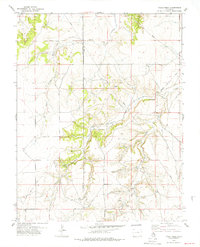
1978 Map of Table Mesa
USGS Topo · Published 1979About this map
Table Mesa dominates this corner of the High Plains along the border of Las Animas and Baca Counties, a landscape where cattle ranching and early commerce left subtle but permanent marks. The historic Granada Santa Fe Trail cuts through the southwestern terrain, reflecting the area's importance as a passage for trade and movement. Scattered water sources like Wyatt Spring, O Hair Spring, and Soldier Spring define the habitable pockets of this arid region, drawing life toward the deep incisions of Freezeout Canyon and Soldier Canyon.
Find a feature on this map
19 named features on this map. Tap any name to fly to it.
Don’t see what you’re looking for? This feature index may not catch every label — zoom into the map to look around manually.
Map Details
Editions of this 1978 Table Mesa Map
This is the sole edition of this map. No revisions or reprints were ever made.
Other maps of this area

1891 · Higbee
USGS Topo · 1:125,000

1891 · Springfield
USGS Topo · 1:125,000

1892 · Two Butte
USGS Topo · 1:125,000

1892 · Mt Carrizo
USGS Topo · 1:125,000

1893 · Higbee
USGS Topo · 1:125,000

1893 · Two Butte
USGS Topo · 1:125,000

1893 · Springfield
USGS Topo · 1:125,000

1955 · La Junta
USGS Topo · 1:250,000

1958 · La Junta
USGS Topo · 1:250,000

1968 · La Junta
USGS Topo · 1:250,000