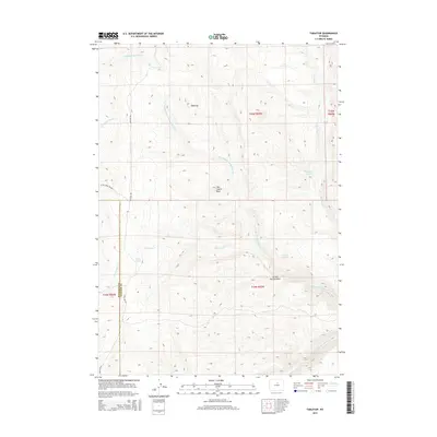
2015 Map of Tabletop
USGS Topo · Published 2015About this map
Tabletop rises as a prominent high point in this 2015 survey of the Bighorn Mountains region, straddling the border of Washakie and Johnson counties. The landscape is defined by the headwaters of several significant drainages, most notably the N Fork Red Fork Powder River and the S Fork Red Fork Powder River. These waterways, along with Beartrap Cr and Baldwin Cr, have carved a complex system of draws and canyons through the high-elevation terrain.
Find a feature on this map
20 named features on this map. Tap any name to fly to it.
Don’t see what you’re looking for? This feature index may not catch every label — zoom into the map to look around manually.
Map Details
Editions of this 2015 Tabletop Map
This is the sole edition of this map. No revisions or reprints were ever made.
Other maps of this area

1955 · Arminto
USGS Topo · 1:250,000

1958 · Arminto
USGS Topo · 1:250,000

1961 · Barnum
USGS Topo · 1:62,500

1962 · Arminto
USGS Topo · 1:250,000

1963 · Mayoworth
USGS Topo · 1:62,500

1966 · Monument Hill
USGS Topo · 1:24,000
1966 · Tallon Spring
USGS Topo · 1:24,000
1967 · Beartrap Meadows
USGS Topo · 1:24,000
1967 · Tabletop
USGS Topo · 1:24,000

1967 · Horse Butte
USGS Topo · 1:24,000