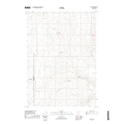
2017 Map of Tabletop
USGS Topo · Published 2017About this map
Tabletop rises as a prominent high-country plateau in the Big Horn Mountains, marking the divide between the Middle Fork Otter Cr and the complex drainage of the Powder River. This 2017 survey details a landscape defined by ranching access and seasonal water sources, where remote tracks like Hazelton Rd and Between The Creeks Rd provide the primary movement across the high range. The map captures the intersection of several notable springs, including Fishers Spring, Curutchet Spring, and Thompson Springs, which have historically served as critical watering points for livestock in this high-elevation terrain. Prominent landmarks such as The Castle Rock and the deeply carved School Section Draw provide distinct navigational points along the N Fork Red Fork Powder River. The boundary between Washakie and Johnson counties bisects the region, following the ridgelines that separate the drainage basins of the Otter Creek and the Red Fork of the Powder River.
Find a feature on this map
21 named features on this map. Tap any name to fly to it.
Don’t see what you’re looking for? This feature index may not catch every label — zoom into the map to look around manually.
Map Details
Editions of this 2017 Tabletop Map
This is the sole edition of this map. No revisions or reprints were ever made.
Other maps of this area

1955 · Arminto
USGS Topo · 1:250,000

1958 · Arminto
USGS Topo · 1:250,000

1961 · Barnum
USGS Topo · 1:62,500

1962 · Arminto
USGS Topo · 1:250,000

1963 · Mayoworth
USGS Topo · 1:62,500

1966 · Monument Hill
USGS Topo · 1:24,000
1966 · Tallon Spring
USGS Topo · 1:24,000
1967 · Beartrap Meadows
USGS Topo · 1:24,000
1967 · Tabletop
USGS Topo · 1:24,000

1967 · Horse Butte
USGS Topo · 1:24,000