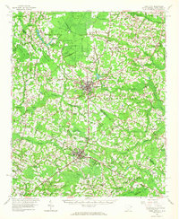
1962 Map of Tabor City
USGS Topo · Published 1965About this map
Tabor City and Loris anchor this mid-century view of the borderlands between Columbus County, North Carolina, and Horry County, South Carolina. The Atlantic Coast Line Railroad provides the primary industrial spine of the region, cutting through a landscape dominated by expansive bay and swamp systems such as Big Bay, Gapway Swamp, and Mitchell Swamp. The settlement pattern follows a dense network of crossroads and small communities, including Cerro Gordo, Fair Bluff, and Clarendon, alongside numerous country churches like Cherry Grove Church and Union Missionary Church.
Find a feature on this map
111 named features on this map. Tap any name to fly to it.
Don’t see what you’re looking for? This feature index may not catch every label — zoom into the map to look around manually.
Map Details
Editions of this 1962 Tabor City Map
This is the sole edition of this map. No revisions or reprints were ever made.
Other maps of this area

1937 · Nixonville
USGS Topo · 1:48,000

1942 · Nixonville
USGS Topo · 1:62,500

1943 · Pages Mill
USGS Topo · 1:62,500

1943 · Pireway
USGS Topo · 1:31,680

1943 · Nakina
USGS Topo · 1:24,000

1943 · Adrian
USGS Topo · 1:24,000

1944 · Longs
USGS Topo · 1:31,680

1944 · Adrian
USGS Topo · 1:31,680

1948 · Bayboro
USGS Topo · 1:24,000

1949 · Bayboro
USGS Topo · 1:24,000