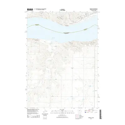
2014 Map of Tabor SE
USGS Topo · Published 2014About this map
Lewis and Clark Lake dominates the central portion of this 2014 survey, marking the watery border between South Dakota and Nebraska. The rugged northern shoreline is characterized by prominent overlooks like Gavins Point, while the southern side reveals a network of residential roads including Park Rd and Mischke Hill Rd that reflect modern development near the water. Inland from the lake, the landscape transitions into agricultural terrain drained by Weigand Cr and Beaver Cr. Local history is preserved at the Frankfort Cem located south of the shoreline, while the presence of the Zisk Reservoir and Stefan Reservoir points to the continued importance of water management in this prairie landscape. The mapping of the Lewis & Clark Trl along the northern bluffs honors the legacy of early exploration in the Missouri River valley.
Find a feature on this map
42 named features on this map. Tap any name to fly to it.
Don’t see what you’re looking for? This feature index may not catch every label — zoom into the map to look around manually.
Map Details
Editions of this 2014 Tabor SE Map
This is the sole edition of this map. No revisions or reprints were ever made.
Other maps of this area

1955 · Sioux City
USGS Topo · 1:250,000

1958 · Sioux City
USGS Topo · 1:250,000

1959 · Sioux City
USGS Topo · 1:250,000

1968 · Tabor SE
USGS Topo · 1:24,000

1968 · Bloomfield NE
USGS Topo · 1:24,000

1968 · Gavins Point Dam
USGS Topo · 1:24,000

1968 · Crofton
USGS Topo · 1:24,000

1974 · Lindy
USGS Topo · 1:24,000

1974 · Bon Homme Colony
USGS Topo · 1:24,000
1977 · Lindy
USGS Topo · 1:24,000
Featured Places
- Northshore Development, SD
- Kohles Acres Area, NE
- Fairview Heights, SD
- Oak Hills Addition, SD
- Utica South Township, SD