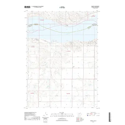
2017 Map of Tabor SE
USGS Topo · Published 2017About this map
Lewis and Clark Lake dominates the northern portion of this landscape, marking the significant impoundment of the Missouri River along the border of Nebraska and South Dakota. This 2017 survey details the complex residential and recreational development along the southern bluffs, where named streets like Mischke Hill Rd, Crooked Oaks, and Hillside Rd indicate a settled shoreline. The terrain transitions south into agricultural land dissected by drainages such as Weigand Creek and Beaver Cr. Genealogical and local interest is centered on the Frankfort Cem located along 895 Rd, providing a physical link to the earlier settlement history of Knox County. Smaller water management features like Zart Reservoir and Steffan Reservoir illustrate the modern rural infrastructure required to manage the area's hydrology away from the main river channel.
Find a feature on this map
36 named features on this map. Tap any name to fly to it.
Don’t see what you’re looking for? This feature index may not catch every label — zoom into the map to look around manually.
Map Details
Editions of this 2017 Tabor SE Map
This is the sole edition of this map. No revisions or reprints were ever made.
Other maps of this area

1955 · Sioux City
USGS Topo · 1:250,000

1958 · Sioux City
USGS Topo · 1:250,000

1959 · Sioux City
USGS Topo · 1:250,000

1968 · Tabor SE
USGS Topo · 1:24,000

1968 · Bloomfield NE
USGS Topo · 1:24,000

1968 · Gavins Point Dam
USGS Topo · 1:24,000

1968 · Crofton
USGS Topo · 1:24,000

1974 · Lindy
USGS Topo · 1:24,000

1974 · Bon Homme Colony
USGS Topo · 1:24,000
1977 · Lindy
USGS Topo · 1:24,000
Featured Places
- Northshore Development, SD
- Kohles Acres Area, NE
- Fairview Heights, SD
- Oak Hills Addition, SD
- Utica South Township, SD