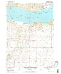
1968 Map of Tabor SE
USGS Topo · Published 1970About this map
Lewis and Clark Lake dominates the northern half of this landscape, reflecting the major mid-century modification of the Missouri River valley for the development of the Missouri River Basin. The water-focused topography includes various recreational and conservation areas like the State Game Refuge and the Sioux Council Boy Scout Reservation. South of the bluffs, the agricultural character of Frankfort and Addison townships is evident through a network of local landmarks. Rural social structures are preserved through sites such as the Crofton United Ch, Frankfort Cem, and local schoolhouses like Frankfort Sch and West Blyville Sch. Significant natural drainage such as Weigand Creek and Beaver Creek cut through the terrain, while industrial activity is noted at the Gravel Pits in the southwest. Near the dam, Gavins Point and the Fort Yankton Historic Site mark the historical and structural importance of this river crossing.
Find a feature on this map
25 named features on this map. Tap any name to fly to it.
Don’t see what you’re looking for? This feature index may not catch every label — zoom into the map to look around manually.
Map Details
Editions of this 1968 Tabor SE Map
2 editions found
Other maps of this area

1955 · Sioux City
USGS Topo · 1:250,000

1958 · Sioux City
USGS Topo · 1:250,000

1959 · Sioux City
USGS Topo · 1:250,000

1968 · Tabor SE
USGS Topo · 1:24,000

1968 · Bloomfield NE
USGS Topo · 1:24,000

1968 · Gavins Point Dam
USGS Topo · 1:24,000

1968 · Crofton
USGS Topo · 1:24,000

1974 · Lindy
USGS Topo · 1:24,000

1974 · Bon Homme Colony
USGS Topo · 1:24,000
1977 · Lindy
USGS Topo · 1:24,000
Featured Places
- Northshore Development, SD
- Oak Hills Addition, SD
- Fairview Heights, SD
- Utica South Township, SD
- North Frankfort Township, NE