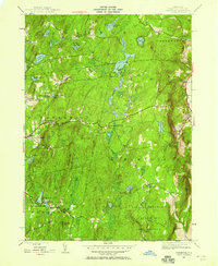
1946 Map of Taborton
USGS Topo · Published 1958About this map
The Rensselaer County highlands are defined here by a dense concentration of glacial ponds and small settlements along the headwaters of the Poesten Kill. In the mid-1940s, the village of Taborton served as a local hub near Big Bowman Pond and Little Bowman Pond, while smaller hamlets like East Poestenkill and Bucks Corner were connected by a network of unimproved dirt roads. The landscape is dotted with markers of early rural community life, including the Fifty Six Cem and Fifty Six Ch in the west, and the Dutch Ch toward the east. This era shows a transition toward conservation and recreation, evidenced by the large Capital District Forest and Game Refuge and the presence of Camp Hiwatha. Geologists and local historians can trace family-named landmarks like Snyder Cem and Perigo Hill across the townships of Grafton, Berlin, and Poestenkill.
Find a feature on this map
39 named features on this map. Tap any name to fly to it.
Don’t see what you’re looking for? This feature index may not catch every label — zoom into the map to look around manually.
Map Details
Editions of this 1946 Taborton Map
3 editions found
Other maps of this area

1888 · Berlin
USGS Topo · 1:62,500

1890 · Berlin
USGS Topo · 1:62,500

1893 · Cohoes
USGS Topo · 1:62,500

1893 · Troy
USGS Topo · 1:62,500

1894 · Berlin
USGS Topo · 1:62,500

1895 · Troy
USGS Topo · 1:62,500

1895 · Cohoes
USGS Topo · 1:62,500

1897 · Hoosick
USGS Topo · 1:62,500

1898 · Berlin
USGS Topo · 1:62,500

1898 · Cohoes
USGS Topo · 1:62,500