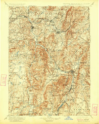
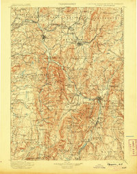
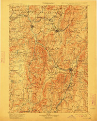
1900 Map of Taconic
USGS Topo · Published 1924About this map
Hoosic River valley settlements serve as the focal point for this late nineteenth-century tri-state survey, where the industrial and transport corridors of New York, Vermont, and Massachusetts converge. The map documents a highly developed rail network crucial to the region's economy, including the Fitchburg R.R. and its passage through the engineering feat of the Hoosac Tunnel. Large manufacturing and trade centers like North Adams, Bennington, and Hoosick Falls are shown alongside smaller agricultural and milling hamlets like Stephentown and Berlin. The topography is defined by prominent elevations such as Mt Anthony and East Mountain, which separate the river valleys from the upland plateaus. For the local historian, the map preserves the location of vanished junctions and depots like Petersburg Junction, while genealogists can trace family-named terrain like Potter Hill and Bingham Hill during a period of peak rural settlement density.
Find a feature on this map
159 named features on this map. Tap any name to fly to it.
Don’t see what you’re looking for? This feature index may not catch every label — zoom into the map to look around manually.
Map Details
Editions of this 1900 Taconic Map
4 editions found

Other maps of this area

1886 · Greylock
USGS Topo · 1:62,500

1886 · Hawley
USGS Topo · 1:62,500

1886 · Chesterfield
USGS Topo · 1:62,500

1886 · Becket
USGS Topo · 1:62,500

1888 · Becket
USGS Topo · 1:62,500

1888 · Berlin
USGS Topo · 1:62,500

1888 · Chesterfield
USGS Topo · 1:62,500

1888 · Pittsfield
USGS Topo · 1:62,500

1889 · Wilmington
USGS Topo · 1:62,500

1890 · Hawley
USGS Topo · 1:62,500