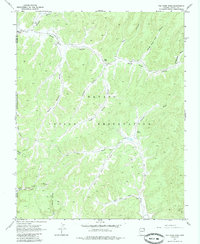
1968 Map of Tah Chee Wash
USGS Topo · Published 1985About this map
The Navajo Indian Reservation landscape documented in 1968 is defined by a complex network of seasonal drainages and named valleys that reveal the hydraulic character of this high desert region. Major watercourses like Tah Chee Wash, Oraibi Wash, and Wepo Wash cut through the terrain, flanked by notable geological features such as Rain Mountain and the distinctive Sitting Giant Rock. The map illustrates the historical infrastructure of the area through numerous water sources essential for survival and livestock, including Coal Spring, Salt Well, and various unnamed wells and springs.
Find a feature on this map
29 named features on this map. Tap any name to fly to it.
Don’t see what you’re looking for? This feature index may not catch every label — zoom into the map to look around manually.
Map Details
Editions of this 1968 Tah Chee Wash Map
2 editions found

Other maps of this area

1883 · Marsh Pass
USGS Topo · 1:250,000

1892 · Marsh Pass
USGS Topo · 1:250,000

1892 · Canyon De Chelly
USGS Topo · 1:250,000

1954 · Shiprock
USGS Topo · 1:250,000

1956 · Marble Canyon
USGS Topo · 1:250,000

1958 · Shiprock
USGS Topo · 1:250,000

1959 · Shiprock
USGS Topo · 1:250,000

1959 · Marble Canyon
USGS Topo · 1:250,000

1961 · Marble Canyon
USGS Topo · 1:250,000
1967 · Burnt Corn Spring
USGS Topo · 1:24,000