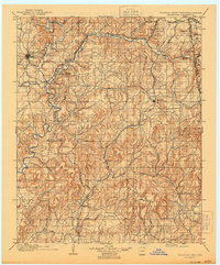
1905 Map of Tahlequah
USGS Topo · Published 1905About this map
The Female Seminary stands as a prominent landmark in Tahlequah at the turn of the century, serving as the cultural heart of the Cherokee Nation. This 1905 edition, compiled from surveys conducted between 1896 and 1901, reveals a landscape defined by the arrival of major rail lines and the established presence of tribal institutions like the Cherokee Orphan Asylum in Parkhill. The St. Louis and San Francisco R. R. and the Kansas City Southern R. R. slice through the rugged hill country, connecting remote settlements such as Stilwell and Westville.
Find a feature on this map
58 named features on this map. Tap any name to fly to it.
Don’t see what you’re looking for? This feature index may not catch every label — zoom into the map to look around manually.
Map Details
Editions of this 1905 Tahlequah Map
This is the sole edition of this map. No revisions or reprints were ever made.
Historical Maps of Titanic Through Time
5 maps found