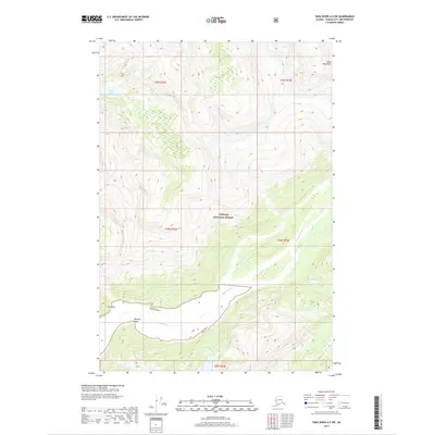
2017 Map of Taku River A-5 SW
USGS Topo · Published 2017About this map
The Whiting River winds through this coastal Alaskan landscape, carving a wide valley floor as it approaches its terminus near Whiting Point. This glacial-carved terrain, situated within the Tongass National Forest, transitions sharply from the alluvial flats of the riverbed to the steep, high-elevation ridges of the Coast Mountains. Small, high-altitude water bodies like Tease Lake sit perched on the benches above the primary drainage, illustrating the complex drainage patterns of the Juneau area. The shoreline is marked by prominent landmarks such as Ox Point, which provides a geographical anchor for navigating the waterway's mouth. This 2017 study illustrates the intersection of maritime influences and massive mountain ranges, where dense forest cover and steep contour lines indicate a wilderness largely shaped by topography and water.
Find a feature on this map
11 named features on this map. Tap any name to fly to it.
Don’t see what you’re looking for? This feature index may not catch every label — zoom into the map to look around manually.
Map Details
Editions of this 2017 Taku River A-5 SW Map
This is the sole edition of this map. No revisions or reprints were ever made.
Other maps of this area

1948 · Sumdum D-6
USGS Topo · 1:63,360

1948 · Sumdum D-5
USGS Topo · 1:63,360

1951 · Taku River A-5
USGS Topo · 1:63,360

1951 · Taku River A-6
USGS Topo · 1:63,360

1951 · Sumdum D-6
USGS Topo · 1:63,360

1952 · Sumdum
USGS Topo · 1:250,000

1953 · Taku River
USGS Topo · 1:250,000

1955 · Sumdum D-5
USGS Topo · 1:63,360

1960 · Taku River
USGS Topo · 1:250,000

1961 · Sumdum
USGS Topo · 1:250,000