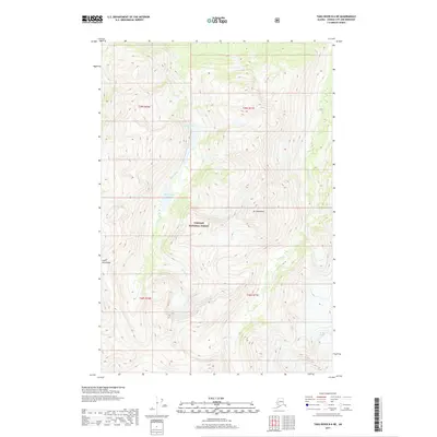
2017 Map of Taku River B-6 NE
USGS Topo · Published 2017About this map
Mt Swineford stands as a central peak in this high-elevation landscape within the Tongass National Forest. The map documents a glaciated wilderness defined by the Coast Mountains, where ice and water dictate the geography. The eastern edge of the quadrangle is dominated by the massive Bridge Glacier, while the central and western reaches are drained by Yehring Cr and Hidden Cr. The concentration of water in the Swineford Lakes basin suggests a highly dynamic drainage system where glacial melt feeds into established creek beds. This 2017 survey provides a precise look at the landforms and township boundaries of the Juneau City and Borough, documenting the extent of ice cover and alpine terrain in the early 21st century.
Find a feature on this map
11 named features on this map. Tap any name to fly to it.
Don’t see what you’re looking for? This feature index may not catch every label — zoom into the map to look around manually.
Map Details
Editions of this 2017 Taku River B-6 NE Map
This is the sole edition of this map. No revisions or reprints were ever made.
Other maps of this area

1951 · Taku River B-6
USGS Topo · 1:63,360

1951 · Taku River B-5
USGS Topo · 1:63,360

1953 · Taku River
USGS Topo · 1:250,000
1960 · Taku River C-5
USGS Topo · 1:63,360

1960 · Taku River C-6
USGS Topo · 1:63,360

1960 · Taku River
USGS Topo · 1:250,000

1994 · Taku River B-6
USGS Topo · 1:63,360

1995 · Taku River C-6
USGS Topo · 1:63,360
2017 · Taku River B-5 SW
USGS Topo · 1:25,000
2017 · Taku River C-6 SW
USGS Topo · 1:25,000