
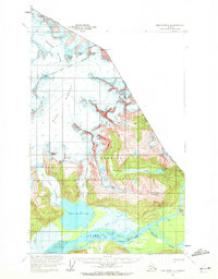
1960 Map of Taku River C-6
USGS Topo · Published 1964About this map
The Taku River corridor defines this remote stretch of the Alaska-Canada border, where the massive ice fields of the Tongass National Forest meet the drainage of the coastal range. This 1960 survey, based on aerial photography from 1948, documents a landscape dominated by active glacial systems including the Bacon Glacier, West Twin Glacier, and the aptly named Hades Highway. The presence of several cabins along the river banks and on Canyon Island points to a specialized economy of trapping or seasonal fishing in an otherwise uninhabited wilderness. Notable landmarks such as Devils Paw and Frostbite Peak line the indefinite international boundary, while the Twin Glacier Lake serves as the terminus for converging ice flows. This map preserves the mid-century extent of these glaciers before decades of significant retreat altered the geography of the Taku watershed.
Find a feature on this map
33 named features on this map. Tap any name to fly to it.
Don’t see what you’re looking for? This feature index may not catch every label — zoom into the map to look around manually.
Map Details
Editions of this 1960 Taku River C-6 Map
2 editions found
Other maps of this area

1948 · Juneau B-1
USGS Topo · 1:63,360

1951 · Juneau
USGS Topo · 1:250,000

1951 · Taku River B-6
USGS Topo · 1:63,360

1951 · Taku River B-5
USGS Topo · 1:63,360

1952 · Juneau B-1
USGS Topo · 1:63,360

1953 · Taku River
USGS Topo · 1:250,000
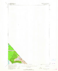
1960 · Taku River C-5
USGS Topo · 1:63,360

1960 · Juneau D-1
USGS Topo · 1:63,360

1960 · Juneau C-1
USGS Topo · 1:63,360

1960 · Taku River
USGS Topo · 1:250,000