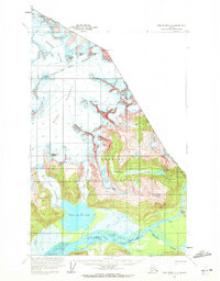
1960 Map of Taku River C-6
USGS Topo · Published 1972About this map
Tongass National Forest dominates this Alaskan landscape, where the international boundary between British Columbia and Alaska cuts through high alpine ice fields and mountain peaks. The map reveals a complex glacial system, with the massive Twin Glacier feeding directly into Twin Glacier Lake and the Bacon Glacier situated further north. The drainage pattern is defined by the Taku River and its confluence with the Wright River, creating a corridor of waterways and shifting gravel bars. Human presence is sparse, represented only by isolated Cabins and a Cabin near the riverbanks, highlighting the remote nature of this border territory in 1960. Distinctive landmarks like Devils Paw and Kluchman Mountain serve as essential navigational markers among the unnamed ridges and high-altitude features like Michaels Sword and The Horn Peaks.
Find a feature on this map
32 named features on this map. Tap any name to fly to it.
Don’t see what you’re looking for? This feature index may not catch every label — zoom into the map to look around manually.
Map Details
Editions of this 1960 Taku River C-6 Map
2 editions found
Other maps of this area

1948 · Juneau B-1
USGS Topo · 1:63,360

1951 · Juneau
USGS Topo · 1:250,000

1951 · Taku River B-6
USGS Topo · 1:63,360

1951 · Taku River B-5
USGS Topo · 1:63,360

1952 · Juneau B-1
USGS Topo · 1:63,360

1953 · Taku River
USGS Topo · 1:250,000
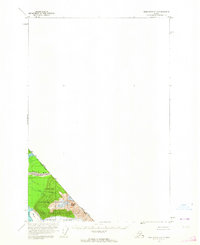
1960 · Taku River C-5
USGS Topo · 1:63,360

1960 · Taku River C-6
USGS Topo · 1:63,360

1960 · Juneau D-1
USGS Topo · 1:63,360

1960 · Juneau C-1
USGS Topo · 1:63,360