
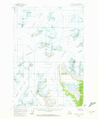
1960 Map of Juneau C-1
USGS Topo · Published 1965About this map
Matthes Glacier and the expansive Taku Glacier dominate this 1960 coastal Alaskan interior, revealing a landscape defined by massive ice fields and high-altitude basins. Within the Tongass National Forest, the map identifies the Nunatak Chalet, a rare human outpost positioned near the Icy Basin. The topography is marked by significant mountaineering and geological landmarks, including the jagged Organ Pipes and the aptly named Hades Highway, which cuts across the upper reaches of Demorest Glacier. This survey captures the region after the 1948 aerial photography and 1960 field annotations, documenting the intricate patterns of crevasses and the southern movements of the North Branch Norris Glacier toward Guardian Mountain. The presence of numerous named peaks such as Centurian Peak and Vantage Peak suggests the importance of this terrain for early surveying and alpine exploration.
Find a feature on this map
25 named features on this map. Tap any name to fly to it.
Don’t see what you’re looking for? This feature index may not catch every label — zoom into the map to look around manually.
Map Details
Editions of this 1960 Juneau C-1 Map
2 editions found
Other maps of this area

1947 · Juneau B-2
USGS Topo · 1:63,360

1948 · Juneau B-1
USGS Topo · 1:63,360

1949 · Juneau B-2
USGS Topo · 1:62,500

1951 · Juneau
USGS Topo · 1:250,000

1951 · Taku River B-6
USGS Topo · 1:63,360

1952 · Juneau B-1
USGS Topo · 1:63,360

1953 · Taku River
USGS Topo · 1:250,000

1960 · Taku River C-6
USGS Topo · 1:63,360

1960 · Juneau D-1
USGS Topo · 1:63,360

1960 · Juneau C-2
USGS Topo · 1:63,360