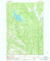
1986 Map of Tamarack
USGS Topo · Published 1986About this map
Lost Valley Reservoir dominates the northwestern terrain of this Idaho-Adams county borderland, serving as a focal point for recreation and water management within the Payette National Forest. This mid-1980s provisional study records the landscape as it transitioned between heavy timber utility and modern outdoor use, featuring a campground, Picnic Areas, and a Boat Ramp near the northern shore. The eastern corridor is defined by the Weiser River valley, where the communities of Tamarack and Pine Ridge sit along the drainage. The map reveals the intricate network of gulches and creeks, such as Slaughterhouse Gulch and Meridian Gulch, that feed into the larger river systems. To the south, the settlement of Evergreen and the Evergreen Campground reflect the continued importance of the Price Valley region for both local residence and seasonal visitors.
Find a feature on this map
36 named features on this map. Tap any name to fly to it.
Don’t see what you’re looking for? This feature index may not catch every label — zoom into the map to look around manually.
Map Details
Editions of this 1986 Tamarack Map
This is the sole edition of this map. No revisions or reprints were ever made.
Other maps of this area

1911 · Meadows
USGS Topo · 1:125,000

1920 · Seven Devils Mining District
USGS Topo · 1:48,000

1938 · Riggins
USGS Topo · 1:96,000

1945 · Riggins
USGS Topo · 1:125,000

1954 · New Meadows
USGS Topo · 1:62,500

1955 · Baker
USGS Topo · 1:250,000

1955 · Grangeville
USGS Topo · 1:250,000

1957 · Cuprum
USGS Topo · 1:62,500

1957 · Hornet
USGS Topo · 1:62,500

1959 · Baker
USGS Topo · 1:250,000