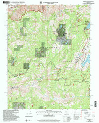
2001 Map of Tamarack
USGS Topo · Published 2004About this map
Bear Valley and the surrounding high Sierra landscape define this 2001 revision, highlighting the modern infrastructure of the Bear Valley Ski Area alongside deep historical layers. The presence of the Bloods Toll Sta Hist Site near Bloods Creek marks a significant waypoint on the old road through the mountains, while the Emigrant Trail skirts the northern edge of the Lake Alpine Recreation Area. This intersection of pioneer-era routes and late-20th-century development is evident in the cluster of seasonal and year-round settlements like Sherman Acres and Skyhigh. The geography is shaped by the transition between the Mokelumne River drainage and the North Fork Stanislaus River, including a series of meadows and reservoirs such as Utica Reservoir and Mattley Meadow that reveal the region's managed water and forest resources.
Find a feature on this map
58 named features on this map. Tap any name to fly to it.
Don’t see what you’re looking for? This feature index may not catch every label — zoom into the map to look around manually.
Map Details
Editions of this 2001 Tamarack Map
2 editions found
Other maps of this area

1889 · Pyramid Peak
USGS Topo · 1:125,000

1889 · Markleeville
USGS Topo · 1:125,000

1891 · Markleeville
USGS Topo · 1:125,000

1891 · Big Trees
USGS Topo · 1:125,000

1891 · Pyramid Peak
USGS Topo · 1:125,000

1893 · Markleeville
USGS Topo · 1:125,000

1894 · Big Trees
USGS Topo · 1:125,000

1895 · Pyramid Peak
USGS Topo · 1:125,000

1896 · Dardanelles
USGS Topo · 1:125,000

1896 · Pyramid Peak
USGS Topo · 1:125,000